Join Jerry from 6:00 AM to 1:00 PM every Monday-Friday morning. Join Crystal from 1:00 pm to 6:00 pm every Monday-Friday afternoon!
Welcome to CHASINTHEBUCK.COM

Forgot Password

Not a Member? Sign up here!

banner
banner
banner
banner
banner
banner

Weather

Spring is close, snow is closer. - Brought to you by The Labascus Armory & Hines Mowing & Welding

98.7 The Buck's Weather Blog is sponsored by the following:

The Labascus Armory - check them out on Facebook, website labascusarmory.com, call 606-706-0189 

Hines Mowing & Welding – check them out on Facebook, or call Adam 606-303-1262 or Colton 606-706-2488.


Spring is right around the corner but that isn’t going to keep winter weather away. Let’s talk about what to expect below:


Sunshine & mild temperatures will remain for Thursday & Friday. Then Friday night is when we will expect to see some snow showers. Snow accumulations are up in the air, model images of the GFS & NAM models through Noon Saturday are below. There is also an image of what the WPC (Weather Prediction Center) is predicting with a 40-70% chance of seeing snow totals of 4” or more. Keep in mind, snow totals vary and are not set in stone and will continue to change.


Confidence is increasing that this could be a Winter Storm for some areas.


After we see snow & colder temps, mild temps & sunshine will make their way back into the forecast Sunday, Monday, & Tuesday of next week. See below:


Thursday – Mostly Sunny; Highs in the mid to upper 50s

Thursday Night – Mostly Clear; Lows in the mid-30s.


Friday – 20% Showers; Mostly Sunny; Highs around 61

Friday Night – 80% Rain/Snow; Lows in the low-20s.


Saturday – 20% Flurries; Partly Sunny; Highs around 30.

Saturday Night - Mostly Clear; Lows in the low-teens.


Sunday – Sunny; Highs in the upper-40s

Sunday Night - Mostly Clear; Lows in the low-30s


Monday – Mostly Sunny; Highs in the upper-50s

Monday Night – 40% Rain; Mostly Cloudy; Lows near 40.


Tuesday – Mostly Sunny; Highs near 60.


If there are any major changes with the models I will be sure to update you on 98.7 & here on our blogs.


Crystal

crystal@shorelinestations.com

A break in the rain ends tonight, Flood Watch issued. Brought to you by The Labascus Armory

98.7 The Buck's Weather Blog is brought to you by The Labascus Armory, check them out today on Facebook & their website at labascusarmory.com.


Today was a bit cooler with high temps only reaching in the upper 30s across much of the area, which was lower than originally forecasted from the mid to upper 40s. Not only did we deal with cooler temps today but we also dealt with a break from the rain but it won't last long as showers return to the forecast tonight as well as a new Flood Watch, details are below:


As stated above, we were able to enjoy a break in the precipitation today as the area was situated between the cold front that pushed through as well as an area of canadian high pressure.

Tonight, precipitation kicks back in as rain chances remain between 90%-100%. This precipitation is due to being ahead of a large upper trough as it moves across the Ohio Valley.

Locally here in South Central Kentucky we will see just rain. Central & Northern Kentucky could get a slight taste of a wintry mix including some light icy precipitation (freezing rain, sleet, snow).

Looking ahead into Thursday, Thursday night, & Friday, a Flood Watch has been issued and will be effective starting at Midnight EST Thursday 2/24 through 7 AM EST Friday 2/25. Please see the graphic below for the counties included in this watch:


Adding additional rainfall on top of the rain we have received over the last 48 hours has the potential for some localized flooding. See below the latest rainfall totals per the Kentucky Mesonet site over the last 48 hours:


Once we get past this wet weather, we will see a drier forecast for the weekend into next week before a slight chance of showers shows up in the forecast again. Below is a short overview of what to expect:

Tonight - 90% Showers - Lows in the mid 30s.

Thursday - Flood Watch in effect - 100% Showers - Highs in the mid 50s.

Thursday Night - Flood Watch remains - 100% Showers - Lows in the upper 30s.

Friday - Flood Watch expires at 7 AM EST - 100% AM Showers - Highs in the mid 40s.

Friday Night - Mostly Cloudy - Lows in the mid 20s.

Saturday - Partly Sunny - Highs in the mid 40s.

Saturday Night - Mostly Cloudy - Lows in the upper 20s.

Sunday - Mostly Sunny - Highs in the upper 40s.

Sunday Night - Mostly Clear - Lows in the mid 20s.

Monday - Sunny - Highs in the mid 40s.

Monday Night - Mostly Clear - Lows in the mid to upper 20s.

Next chance of showers will be Tuesday night currently showing at 20%.


Keep in mind the forecast is subject to change and when it does I will be sure to update you on 98.7.


-Crystal

crystal@shorelinestations.com

Wind, Showers, Storms, Oh My! - Sponsored by The Labascus Armory - 2/16/22

98.7 The Buck's Weather Blog is brought to you by The Labascus Armory, check them out today on Facebook & their website at labascusarmory.com.


Good Tuesday night folks! Enjoy the spring-like & breezy conditions while they last because we have showers, storms, & colder temperatures on the way. Heres the rundown:


A Wind Advisory will be effective from 7 AM - 7 PM EST Wednesday February 16th for our area. Wind gusts up to 45 mph will be expected. In return this could cause possible power outages as well as tree limbs being blown in the road way. Use caution if you drive a high profile vehicle as well.


The possibility remains for that Wind Advisory to carry over into Thursday, or it will be upgraded to a High Wind Watch or Warning. Ill keep an eye on that.


Thursday, we have showers & storms in the forecast for our area. As this system pushes through, some areas could see 1" up to 2" of rain. Locally I would forecast up to 0.75". The increased rain amounts would be to our South West. I will continue to monitor this as well.


Once this system pushes through, we will go from mid 60s Thursday afternoon down to the mid 20s overnight into Friday morning as your lows. Friday high temps only near 40. But the good thing about this is by Sunday we will be back around 60 degrees so the colder temps won't last long.


Weekend weather forecast looks great with plenty of sunshine, below is a look at the forecast:


I will continue to monitor & update as needed as always on 98.7. As always feel free to email me anytime with any questions you may have. Depending on the changes, keep an eye out on our Facebook page for live weather updates via video!


-Crystal

crystal@shorelinestations.com

Warmer Temps Won't Last This Weekend - Brought to you by The Labascus Armory

98.7 The Buck's Weather Blog is brought to you by The Labascus Armory, check them out today on Facebook & their website at labascusarmory.com.


Good mid-week Wednesday folks! It has been calm this week in the weather world. Mild temperatures & plenty of sunshine is the perfect forecast compared to what we have dealt with in the last few weeks.


Don't get too spoiled to the mild temps tho because a cold front will make its way across the area this weekend. Friday's high temps will top around 60 & by Sunday, high temps will be around the mid-30s. Oh & might I mention, we have the potential for a light snow event this weekend, let me give you the rundown.


So I will be showing you the NAM & GFS models in this blog (yes there are many others but I am just choosing 2 to keep it simple).

Above is the NAM model that shows forecast snow totals through 7 PM EST Saturday evening. As you can see some local areas are showing little to nothing. As we look into Russell, Pulaski, & counties South, there is a bit of accumulation of around 1', give or take. Now let's take a look at the GFS model below:


All of you who are not as much of a snow lover as others, depending on where you live, might like the GFS a bit better. This GFS screenshot is good through Sunday at 1 PM EST. Snow accumulations are lesser at less than 1" for our local area.


All in all even tho the accumulations are showing different on each model, the one things these models have in common is the POTENTIAL for a light snow event.


I will continue to monitor data & model trends and keep you updated. You can catch your updates on air on 98.7, here on our website, & even on Facebook (be sure to like & follow us). Until the next time, enjoy the sun & mild temps!


Crystal

crystal@shorelinestations.com

11 PM Update for Flooding Potential & Winter Storm - Brought to you by the Labascus Armory

11:00 PM Weather Update is sponsored by The Labascus Armory.


Good Tuesday evening. We had some beautiful weather earlier today, I hope you was able to get out & enjoy it because changes are on the way. The calm before the storm....... as they say.


Flooding Potential:

Let’s talk flooding potential first.

Rain chances will be low tonight into your early morning hours Wednesday, around 20-30% chance.  As we get into Wednesday, the surface cold front will push its way into parts of Kentucky. Rain chances increase to 90-100% & should be fairly consistent throughout the day. NWS Louisville is forecasting rain totals from 2.5” to 3.5” for some areas. This will in return cause excessive runoff which in return will cause some localized flooding. Rain will continue into Thursday as rain before transitioning over to freezing precipitation & snow (for parts of the state). I will be monitoring updates for the possibility of a Flood Watch being issued.


Winter Storm:

After our flooding potential, comes this winter storm I have been tracking. NWS has already issued a Winter Storm Watch to take effect from Thursday morning into Friday morning including counties in South Central, Central, Northern, & Northwestern Kentucky. As of now the farthest south that watch extends is in Pulaski County.

A surface cold front will slowly move into parts of the state overnight Wednesday & continue to push across into Thursday morning. Models depict a sharp surface temperature gradient with the front & precipitation will transition from rain to a mix of wintry precipitation (sleet/freezing rain/snow). The front will continue to push its way across the state into Thursday night when it will clear the region. Temperatures will be lucky to get at 32 degrees as the high on Friday, Friday night lows will be in the teens.


Timing of Precipitation Transition:

Timing is not set in stone even though models continue to update. The most recent trends are showing the cold front arriving faster than prior updates. If the cold front does indeed arrive faster, there will be a quicker transition from rain to wintry precip. The front could slow down as it moves across the region, which could cause increased freezing rain & sleet rates. Keep in mind most of the snow will stay to our North/Northwest. Areas between the Bluegrass/Western Kentucky Parkway and areas from the parkway to I-64 could see a spike in the freezing precip. After all this, the front will work its way out of the region early Friday morning.


Precipitation Types & Where:

Latest model runs (GFS & NAM) are showing a bit of a difference in who gets ice and who gets rain LOCALLY. Again most of the snow precipitation will be to our North and northwest.

Last run shows the GFS model depicting ice & rain for our local area. The NAM model depicts us getting less ice and more rain. If this system moves and goes more towards the GFS model, ice totals could be up to ½” for some places.


Preparedness:

I am not saying this to cause hype or to make this system out worse than what it will be, but be safe than sorry folks.

Now is the time to get what you need from the grocery store (don’t be hoggish), get needed medications, generators, source of heat, update your emergency kits, make travel reservations as travel will be impacted for certain Thursday night into Friday. Just use common sense. Be sure to keep your mobile phones charged, have fuel in your vehicles, a source to receive the latest weather updates, etc.


Final Thoughts:

I will continue to pass along updates as they come in. NWS will be holding not one but TWO conference calls tomorrow, so I will be sure to pass along the latest information here.


Also keep in mind, models have been going back and forth, like a game of tennis, in where exactly this line of ice will hit. These models WILL continue to change up until the day of this event. Winter weather is harder to follow & forecast compared to your thunderstorms.


Don’t forget to listen for weather updates on-air on 98.7 on your radio dial. You can also listen off of the free app Simple Radio and here on our website chasinthebuck.com. Of course if you’re big on social media following pages, be sure to follow us on there as well Classic Country 98.7 The Buck “WKDO”.


If you have any additional questions feel free to email me at crystal@shorelinestations.com


-Crystal

Flooding & Winter Storm Update - Brought to you by The Labascus Armory

12:40 AM Weather Update:
Sponsored by The Labascus Armory

Flooding & Freezing Rain Potential

Model data shows some agreeance to an extent, as the latest updates come through tonight. Let’s take a look at timing, what to expect precipitation wise, & what questions are still left unanswered as of tonight.

TIMING:
Slight rain chances will make their way into the forecast Tuesday night, currently showing about 30-40% chance locally.

Rain chances increase Wednesday to 90-100% & will remain that way through Thursday. This will cause some flooding issues for some areas. Rain totals of 2.75”-3” are expected across the area.

Thursday will be the big day of change as this system pushes through with the arctic air behind it. Temperatures may start out fairly warm but will drop significantly as the day progresses. The transition of rain to freezing rain/sleet looks to take place throughout the afternoon into the evening. As the evening and night progresses precipitation will transition to all freezing rain, into the early morning hours on Friday.

PRECIPITATION:
Locally, we will definitely rain/freezing rain/ sleet. If we see snow it will be light. Our neighbors to our North on the other hand, has a better chance of snow compared to us.

UNCERTAINTIES:
Just a reminder, agreeance with models will get better the closer we get to this system, especially about 24-36 hours out.

As of tonight, questions that remain unanswered are:
1) How much precipitation will we get?
2)Which type of precipitation will remain fairly dominant for our local area?
3)How fast will this arctic air move?
4)How far South will this arctic air go?

Hopefully tomorrow I can have answers to the questions above.

FINAL THOUGHT:
This will be an impactful winter event, so prepare now if you can. If you need items, get them (do not be hoggish).
Always remember, rather be safe than sorry.

I’ll continue to monitor and keep updates posted as needed.


Contact me:

crystal@shorelinestations.com


-Crystal
 

Winter Weather Advisory - This Evening into Tomorrow Morning - Brought to you by The Labascus Armory

Your weather blog is brought to you by The Labascus Armory - located on KY 501 in Casey County. Go visit Chad Davenport & the crew today! 


The next system to bring some snow to the area is still on track. Today we will have a 90% chance of rain across the area that will later transition to snow. The transition time should occur during the evening hours, this evening.


Models are staying pretty consistent without any major changes.


A Winter Weather Advisory will be in effect this evening through Thursday morning. See the graphic below courtesy of NWS Louisville:


Also from NWS Louisville is another graphic that outlines the timing for areas who would most likely see snow from 7 PM EST Wednesday - 4 AM EST Thursday.


Be sure to share out this information, as well as, listen on air on 98.7 on your radio dial, listen live off our website here or even download the free Simple Radio App on your mobile device. Don't forget to also check out our Facebook page as well.


I will monitor & share the latest to keep you informed.


-Crystal

crystal@shorelinestations.com


More Snow On The Way? - Brought to you by The Labascus Armory

Your weather blog is brought to you by The Labascus Armory - located on KY 501 in Casey County. Go visit Chad Davenport & the crew today! 


After receiving anywhere from 2-5" of snow across the listening area since Sunday morning, could we be in the mix for additional snow midweek? Let's take a look.


The latest weather data shows that widespread rain is expected to develop ahead of another cold front midweek this week.

As the front moves through Wednesday, colder air will enter the area making the possibility of seeing rain transition over to snow. NWS terminology states "minor accumulations are possible", so I will go ahead and call as of today a dusting up to 3" would be possible for our area.


I will continue to keep an eye on the latest models, which I will not include in this blog today because being 3 days out, will just cause a lot of hype.


Keep an ear tuned in to 98.7 & eyes opened to our weather blogs & Facebook page, & I will keep you informed of the latest updates.


In the mean time, I would love to see your snow pictures! Who knows they may end up on our Facebook Page! Send your photo (1 per person please), name & location via email only to crystal@shorelinestations.com.


-Crystal

crystal@shorelinestations.com

1/12/22 - Real Weather Talk No Hype Allowed - Brought to you by The Labascus Armory

Your weather blog is brought to you by The Labascus Armory - located on KY 501 in Casey County. Go visit Chad Davenport & the crew today!


Happy Wednesday folks! I want to talk real weather talk today, no hype is being allowed.


Looking on social media I have seen multiple posts that have been made and even shared across hundreds and thousands of folks that is just what I like to call "hype" posts.


What are hype posts? Posts/information that exaggerates on what the actual weather events/conditions could or will be. For example, these posts I have seen today are showing only one model & this model shows 12" of snow forecasted this weekend.


When your forecasters mention or say "we are keeping an eye on model & data trends..." for a weather event, usually that means before they share any additional specifics including snow totals, they are watching the different models because more than likely they are inconsistent or are too far out for a weather event. Therefore the word "trends". Oh & by the way these hype posts I am referring to are for a snow event for this weekend.


I try to share and give the most ideal details and forecasts for our LOCAL area. I say LOCAL in all caps because tv stations and other news media will focus more on the bigger cities & towns compared to us smaller ones.


So with all of that being said, within the next week or so I will be breaking down and sharing what models are used the most with certain weather & which of these models are more accurate compared to the ones that are used to hype up weather information & forecasts.


Before I end this blog, lets go ahead and take a look at our forecast into the weekend. This forecast is the latest as of 1:50 PM here on January 12, 2022:

Tonight: Partly Cloudy, Lows in the low 30s.

Thursday: 20% Rain, Mostly Cloudy, Highs in the mid 40s.

Thursday Night: Mostly Cloudy, Lows near 30.

Friday: Mostly Cloudy, Highs in the low 40s.

Friday Night: 20% Snow after 1 AM, Mostly Cloudy, Lows in the mid to upper 20s.

Saturday: 50% Precip (Rain & Snow) Mostly Cloudy, Highs in the mid 30s.


If you ever have any questions/comments/concerns or even suggestions on what you would like to see a blog to contain, feel free to email me any time at crystal@shorelinestations.com.


Have a great Hump Day! Thanks for sharing!


Crystal

crystal@shorelinestations.com

Weather Outlook - Jan. 11 - Jan. 15 - Brought to you by The Labascus Armory

Happy 2022 & welcome back to your weather blog here on 98.7 The Buck!


Your weather blog is brought to you by The Labascus Armory - located on KY 501 in Casey County. Go visit Chad Davenport & the crew today!


2022 has been a bit of a roulette table in the weather world across the listening area. Started off New Years Day with tornadoes, a week later we experienced flooding, then to top it off last week we dealt with multiple inches of snow.


Let's take a look at our week in weather this week for the listening area:

For the rest of your Tuesday afternoon it looks like sunny skies will continue. That sun will underestimate how warm it looks outside tho, todays high temps will be right around 39 degrees.


Tonight: Mostly Clear, Lows near the upper 20s.

Wednesday: Mostly Sunny, Highs near the upper 40s.

Wednesday Night: Mostly Cloudy, Lows near 30.

Thursday: Partly Sunny, Highs in the mid 40s.

Thursday Night: Mostly Cloudy, Lows in the mid to upper 20s.

Friday: Partly Sunny, Highs near the low 40s.


One thing I am keeping an eye on is our weather for Saturday. We do have a 60% chance of precipitation which will include snow, but as of now there is no accumulation forecasted. Snow will mix with rain in the morning Saturday than transition to all rain. Saturday high temps will be near 40.


So overall this week, weather is dry but cooler until we get to your weekend.

I will keep you updated with the latest weather details right here.


-Crystal

crystal@shorelinestations.com

SEVERE WEATHER EXPECTED TONIGHT 5/3/2021 THROUGH TUESDAY EVENING 5/4/2021

Severe weather is expected for the region overnight tonight through Tuesday evening. Below are a couple of slides issued from the NWS Conference Call held earlier this afternoon.


Please be sure to stay weather aware & as always we will have you up to date with the latest weather information and live weather coverage from The Buck Weather Center, right here on 98.7 The Buck!


If there are any additional updates to pass along I will make a new blog & share it to our Facebook Page!

Thanks!


-Crystal

-crystal@shorelinestations.com

WEATHER UPDATE - APRIL 20, 2021

It’s been awhile since I have been able to post a blog but since Kentucky weather is being the typical Kentucky weather, I have some updates to pass along this evening.


Hopefully, ya’ll were able to enjoy the warmth and sunshine over the last couple of days because we will experience about a 20 degree drop in high temperatures by this time tomorrow.


For tonight we have an 80% of seeing showers, both rain AND snow showers. That’s right, SNOW showers for overnight hours. Little or no snow accumulation is expected, it’s too warm anyways for any of that to stick. Lows tonight will be just around freezing, 32-33 degrees.


A Freeze Watch will be effective Thursday morning from 2 AM EST to 10 AM EST. A Freeze Watch means that sub-freezing temperatures will be likely. Freeze conditions could kill sensitive vegetation and possibly damage unprotected outdoor plumbing.


Take steps now to protect tender plants from the cold. To prevent freezing and possible bursting of outdoor water pipes, they should be wrapped, drained, or allowed to drip slowly. Those that have in-ground sprinkler systems should drain them and cover above-ground pipes to protect them from freezing.


Moving on to take a look at the forecast for this weekend into the beginning of next week, I promise it gets better, we will be dealing with frost overnight Wednesday & Thursday. Then some showers & storms on Saturday. Here is the better news, by next Tuesday we should see 80 degrees! So a warm up is on the way. Take a look at your more detailed forecast below:


Wednesday – 30% AM Rain; Cloudy becoming mostly sunny; Highs around 50

Wednesday Night – 20% Showers in the evening; Frost overnight; Lows in the low 30s


Thursday – AM Frost; Mostly Sunny; Highs around 55

Thursday Night – Frost overnight; Mostly Clear; Lows around 33


Friday – AM Frost; Partly Sunny; Highs around 62

Friday Night – 60% Showers; Mostly Cloudy; Lows in the mid 40s


Saturday – 80% Showers/Storms; Highs around 60

Saturday Night – 70% Showers/Storms; Lows around 44


Sunday – Partly Sunny; Highs in the mid 60s

Sunday Night – Mostly Clear; Lows around 40


Monday – Sunny; Highs around 73

Monday Night – Mostly Clear; Lows around 50


Tuesday – Mostly Sunny; Highs around 80.


Don’t forget your forecast is subject to change.


If there are any major changes, I will be sure to update with a new blog!


I would love to see some of your spring pictures, you can email them to crystal@shorelinestations.com who knows you may see yours on our forecast graphics!


-Crystal

SEVERE WEATHER THREAT FOR THURSDAY 3/25/2021

Good Wednesday afternoon/evening folks. It has been a while since I have posted a weather update here within our blogs. It has been somewhat calm for the most part & as of tomorrow that looks to change since we do have a chance for severe weather in our local area.


Let’s get down to what we are watching for your Thursday:


The latest update has our area in a SLIGHT Risk for severe weather tomorrow (timing is currently from 3 PM to Midnight Eastern time, I will go into those details below). See below of the category definitions in regards to risks:


The main threats with these storms are damaging winds & even an isolated tornado, possibly for the South-Central KY area.


Now as of timing, as stated above, the time frame is currently at 3 PM through Midnight tomorrow & this is Eastern time. (also see attached graphics courtesy of NWS Louisville):


Thursday Morning – Early Afternoon – Could see some widespread showers & a few pop up thunderstorms, and we can’t rule out seeing brief heavy rainfall that could lead to some localized flooding issues.


Thursday Late Afternoon 2 PM – 7 PM Eastern Time – Southern KY will see scattered storms, a few of these storms could produce damaging winds & hail. We also cannot rule out an isolated tornado in the South-Central KY area, as mentioned above.


Thursday Evening – We will see a broken line of storms. These storms will still have the chance to be severe meaning we cannot rule out the threat of damaging winds or brief spin-up tornadoes. The severe threat will diminish as the night goes on by Midnight.


Overnight Thursday – As the severe weather threat diminishes, gusty winds will remain overnight. Sustained winds around 15-25 mph & gusts up to 35 mph are possible.


I will continue to monitor the latest forecasts & data & provide updates as needed here & on-air on 98.7 The Buck. As always we will have your live weather coverage from The Buck Weather Center when severe weather strikes.


If you are a business and would like to sponsor our weather blogs here on The Buck, be sure to send me an email and we will get you taken care of. Your business name & logo will be mentioned anytime our weather blog is mentioned and thousands of folks will see your name on social media platforms.


-Crystal

crystal@shorelinestations.com 

3:00 PM Update 2/17/2021 - Winter Storm Warning

A third winter storm will move in and affect parts of the region this evening into the overnight/early morning hours. A Winter Storm Warning will take effect at 7 PM EST / 6 PM CST this evening through 7 AM EST / 6 AM CST Friday morning, with a chance of this warning being cancelled prematurely once this system pushes through.


Snowfall amounts of 2-4" / 3-5" for our local area is what is in store to be received overnight tonight, Ice accumulations of 0.10" is also expected for the local area along with the snow.


This system will start off with snow this evening/oernight then will transition to sleet/freezing rain into the overnight early morning hours then to freezing drizzle by tomorrow mid-morning/afternoon.


Below are the most updated slides from the NWS conference call held at 2:30 PM this afternoon:


WARNINGS & ADVISORIES FOR THE STATE,


WINTER STORM TIMING


SUMMARY OF WHAT TO EXPECT


A LOOK AT END OF THE WEEK LOW TEMPS - BE CAUTIOUS OF INCREASED CHANCE OF FROSTBITE & HYPOTHERMIA IF HAVING TO BE OUTDOORS FOR AN EXTENDED PERIOD OF TIME,


Some positive news towards the end of the weekend on Sunday as we will not see sunshine but also high temps in the 40s, which in return will cause continuous melting. There is another system coming into the area Sunday night/Monday morning but this system will be mostly a rain system. There will be a slight chance of snow showers but it will be mostly rain, a cold rain at that.


By Tuesday we could see high temperatures around 50 degree.


I will keep you updated.


Stay safe, stay warm folks!


-Crystal

crystal@shorelinestations.com

11:40 AM Tuesday February 16, 2021 - More Winter Weather

First off, I want to give a huge THANK YOU, to all of our line men & women, county road crew, state road crew, healthcare workers, essential workers, & anyone else who has to be out in this weather. For you guys and gals, we are truly thankful & appreciative! Prayers for your safety! A friendly little note, to help your mail carriers out, be safe while doing so, but try and knock off the ice on your mail box so they don't have to fight that battle. Also if you see any of these men & women out, pay it foward with a drink or meal, or even a Thank You, it goes a long way.


We have finally made it through this first winter system, now are you prepared for a second?

That’s what is on the table for late Wednesday night/early Thursday morning into late Thursday night/early Friday morning. Snow, sleet, freezing rain, & cold rain will all be on the table for this second system as it moves in late tomorrow night/early Thursday morning. Again just like with this winter storm from yesterday, uncertainty remains for which areas will receive what exact precipitation.


Expect a Winter Weather Advisory to be issued later on today for parts of the region.


Locally we are forecasted to receive 2-4” of additional snowfall on top of what we have already received this week. Below I have posted a couple of models with “predicted” snowfall totals, the NAM & GFS models. (These are just to show the difference, as we all have seen, from the start of the talk of the last storm until it got here, ALL forecasts from weather folks (including myself) even NWS was off. Winter weather stinks because of this.)


This is a look at the GFS Model through Friday at midnight.


This is a look at NAM model through Friday at midnight.


Also here is a look at a couple of updated briefing slides from the NWS:


As you can tell, there is quiet a bit of difference between the NAM & GFS models when it comes to snow totals. Again ideally, a range of 2-4" is more realistic for our area especially since we will be dealing with warmer temperatures.


Let's take a look at the detailed/extended forecast into this weekend:


Today - Flurries; Mostly Cloudy - Partly Sunny; Highs in the low 20s with wind chill values around 4.

Tonight - Mostly Cloudy; Lows around 10 with wind chill values around 0.


Wednesday - 30% Afternoon Snow Showers; Mostly Cloudy; Highs in the low 30s. 

Wednesday Night - 90% Snow/Freezing Rain; Mostly Cloudy; Lows in the mid to upper 20s. New snow totals of 2-4" possible.


Thursday - 90% Freezing Rain/Snow/Rain; Cloudy; Highs in the low to mid 30s.

Thursday Night - 50% Snow Showers; Cloudy; Lows in the mid to upper teens.


Friday - Mostly Cloudy & Cold; Highs in the mid 20s.

Friday Night - Mostly Cloudy; Lows in the single digits.


Saturday - Mostly Sunny; Highs in the low to mid 30s.

Saturday Night - Partly Cloudy; Lows around 20.


Sunday - Mostly Sunny; Highs in the low 40s.


Again, this forecast will change & I will provide updates the best that I can on-air, on our Facebook page ( https://www.facebook.com/Classic-Country-987-The-Buck-WKDO-610411902307145 ). If you have any questions, comments, or concerns, you're more than welcome to send me an email & I will answer and help out the best that I can.


-Crystal

crystal@shorelinestations.com


6:30 PM Update - February 14, 2021 - Winter Storm Warning

Good evening, folks. Crystal here with another update in regards to our winter storm event that has already started to move into the state.


One thing I would like to reiterate is that this storm will have 2 waves. The first wave of this system will have widespread precipitation developing by midnight, some of which has already moved into our local region this evening. While the northern part of the state into southern Indiana will see snow with this first wave, south of the river & northwest of the Bluegrass/Western Parkways will see sleet/snow mix. Southeast of the Parkways will see more freezing rain. The areas seeing snow from this first wave will be an average of 1-3". Ice totals will possible up to 1/4". Precipitation is expected to decine by mid-morning tomorrow, which will allow a small break before this second wave makes it way in.


Moving on to the second wave, this will be a more significant wave and pack a punch so to speak. For our local region here in South Central Kentucky, we should see this arrive by tomorrow afternoon around Noon to 1 PM EST. This wave will continue to push it's way through the rest of the state as your afternoon/evening goes on. There will be more of a colder air with this wave compared to the first wave therefore the transition of snow/sleet/freezing rain will shift more towards the East as the days goes on into the evening and night hours.


I have attached within this blog, are the latest slides issued from NWS as of 5:27 PM EST (please pay attention to the date & time of these blogs and slides so you are not confused).


As you can tell with these updated slides, the snow accumulation has decreased a bit for some areas, I am still sticking with my previously mentioned total range of 4-8". Ice accumulations continue to change, areas could see up to 1/4" while others can possible see up to 1/2". If you notice, those areas with the higher snow totals will have a decreased ice total & those areas with a higher ice total have a decreased snow total. It's all about the movement of the warm air & cold air.


I will be sure to update with another blog if there are any other MAJOR changes with this system the closer it moves to our area. Until then I hope everyone has made their necessary preparations especially since power outages are bound to take place with this system. 


I will go ahead and say after this system there will be a small break Tuesday night into Wednesday before another system brings in more snow/sleet/freezing rain Thursday (I am monitoring).


Please be sure to check on the elderly, make sure outdoor pets/livestock are taken care of, & it doesn't hurt to have multiple emergency kits made up for home & for each vehicle (including filling up on fuel).


I will update when needed. Thanks for following & sharing!


-Crystal

crystal@shorelinestations.com


12:45 PM UPDATE: Sunday February 14, 2021 - Winter Storm Warning

Good Sunday afternoon, here is an update from the 11:30 AM Conference Call held with the National Weather Service (NWS):


Updated NWS Briefing Slides Attached


•Winter Storm Warning effective from 7 PM tonight - 1 PM Tuesday. Snow accumulations still ranging from 4-7" with ice accumulations remaining up to 0.25".


•Locally we will have this system move into our area late tonight / early tomorrow morning.


•Most freezing rain will be overnight from Burkesville, Columbia, Jamestown, to Liberty. Total ice ranges showing 0.01 up to possible 0.25 for these areas all the way into the Eastern part of the state. Far east from Jackson to Pikeville shows ice totals ranging from 0.25 – 0.50.


•Uncertainty remains with some totals in exact locations.


•Adjustments to totals & forecasts are possible permitting how this system’s path pans out.


•After this system moves through and we get a break Wednesday, there will be another system that moves through the area Wednesday night into Thursday. Will update once updates are received.


You are more than welcome to send me any questions you may have to crystal@shorelinestations.com


Be Prepared folks!


Sunday February 14, 2021 - WINTER STORM WARNING

Happy Valentines Day folks. If you are looking for some Valentines plans to do with your sweetie, well you may want to go and start making preparations (if you haven't already), as that Winter Storm Watch has been upgraded to a Winter Storm WARNING.


As stated in my previous Facebook posts, accumulations I was expecting for our local area were between 4-8" other areas 3-6", well NWS has stated with this warning that snow accumulations have been updated for 4-7".


Let me give you the details below along with the most updated briefing slides:


A winter storm system will bring two waves of wintry precipitation to the region tonight through Tuesday. There could be significant accumulations of snow, sleet, & possible freezing rain. The heaviest precipitation is expected to occur onday afternon into Monday night.


Winter Storm Warning will take effect at 7 PM EST /6 PM CST this evening Sunday February 14, 2021 & go through Tuesday at 1 PM EST / 12 PM CST February 16, 2021.


What: Total Snow & sleet accumulations are forecasted at 3-7" and ice accumulations between a light glaze & 0.25".


Impacts: Travel could be very difficult to impossible. The hazardous conditions could impact the morning/evening commute.


If you MUST travel, keep an emergency kit on hand and stocked with a flashlight, batteries, blanket, food, water, medication, & other items to  suit your needs.


You can stay updated here, on air on 98.7, on my personal Facebook page as well as The Buck's Facebook page (Classic Country 98.7 The Buck) for live video updates as they come in.


-Crystal

crystal@shorelinestations.com


Friday February 12, 2021 - MORE WINTER WEATHER FORTHCOMING!

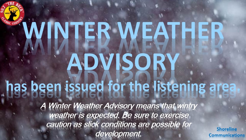
Good Friday afternoon folks! It has been a hectic week in the weather world & it looks like that will be the trend as we look into late Sunday night into Tuesday for another winter weather event and then again later in the week on Thursday.


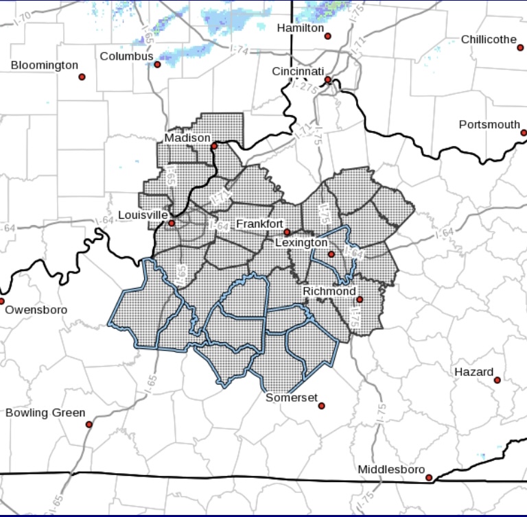
Please keep in mind, our main goal is to focus here LOCALLY on our local areas such as Casey, Taylor, Boyle, Lincoln, Pulaski, Adair, Russell, & Marion counties plus others. DO NOT feed into the hype if you see fake sources mentioning out of the ordinary amounts of snow. ALWAYS read your articles in their entirety to fully understand what can happen and what is possible as totals show different with different models and are ALWAYS changing.


So since that has been mentioned, let’s get down on what to possibly expect for this second round of winter weather, keep in mind like the last event we had the forecast is definitely subject to change. Thanks to the long-term AFD, we are better able to explain this in simple terms. 


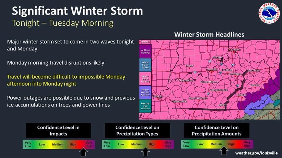
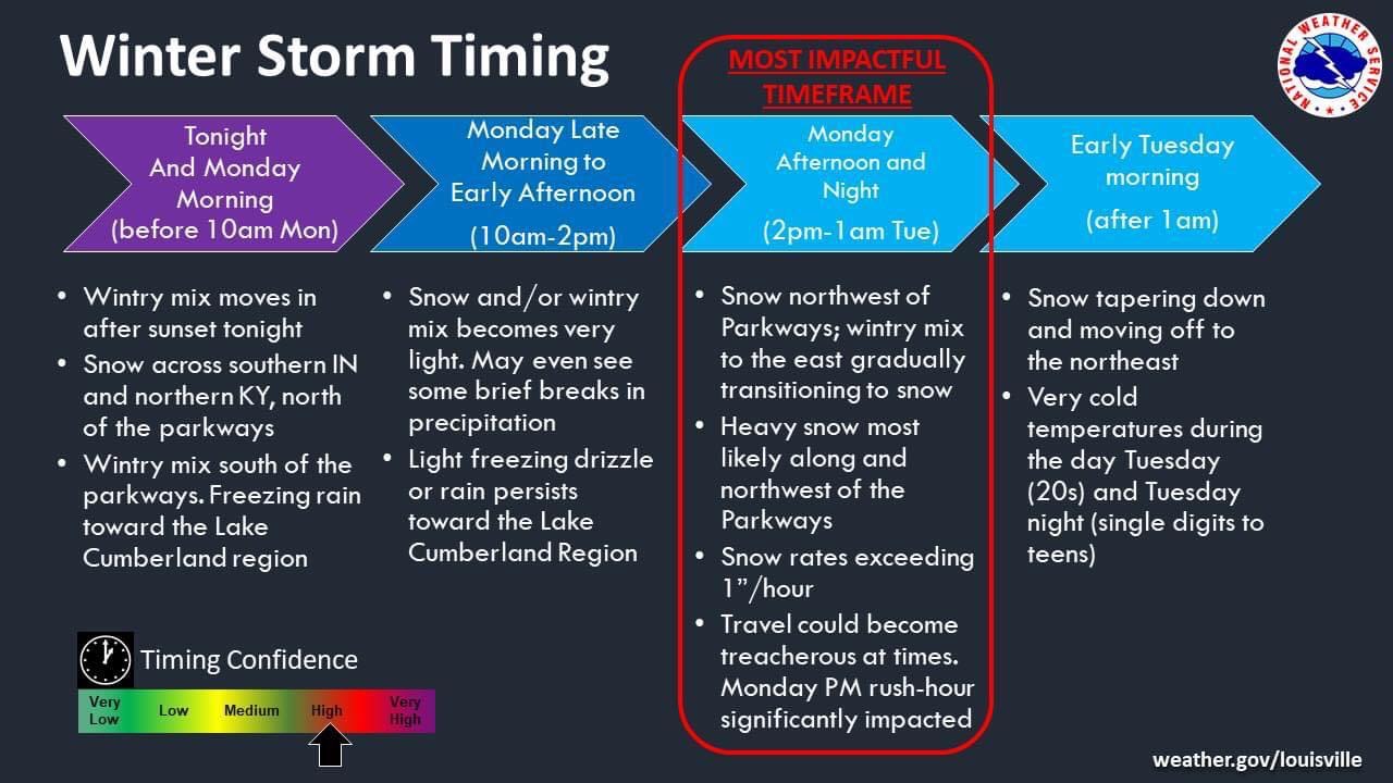
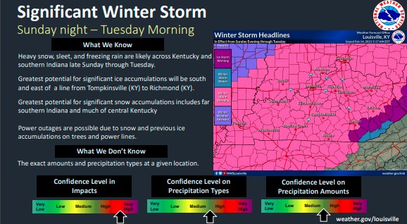
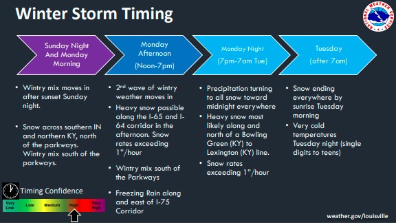
So the main focus is on a system that will actually come in two waves. The first wave will arrive late Sunday night/early Monday morning.  


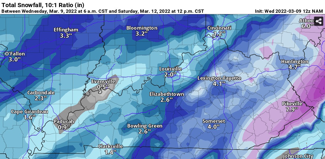
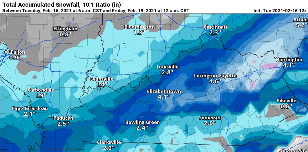
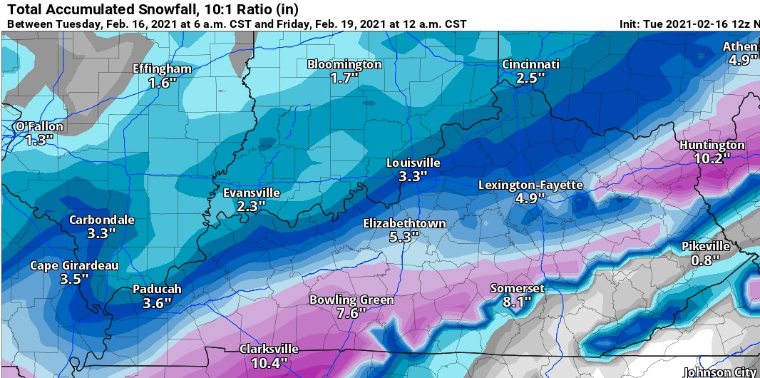
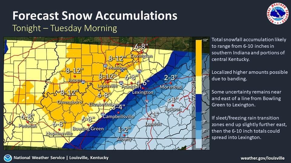
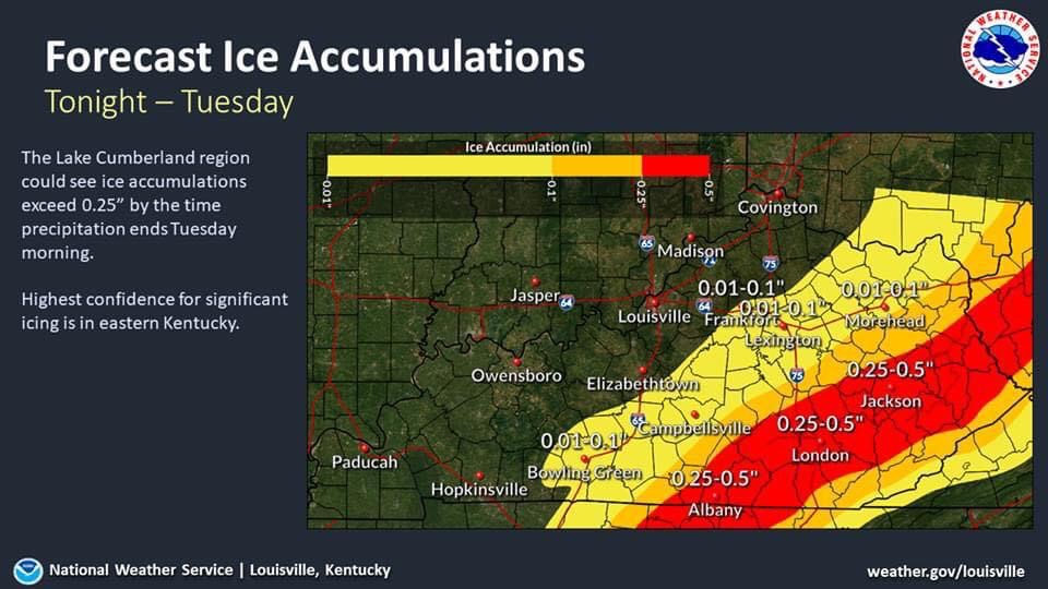
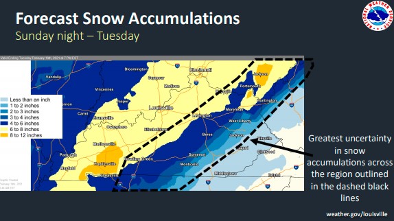
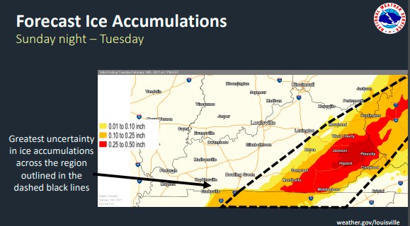
The second wave, which has a possibility of being stronger will arrive Monday night into Tuesday morning. Now unlike our ice event we had Wednesday evening into early yesterday morning, this system will be more of a wintry mix due to the increase of moisture it has. Now which areas will get what kind of precipitation? That is still uncertain but I will continue to keep a close eye on the track of this system, as well as model trends. As of right now, to give an idea, for much of the state, we will see a mix of snow & sleet. However, we could see a mix of freezing rain & sleet south of the parkways. Preciptitation totals will be very SIGNIFICANT, so it would be a good idea to start preparing and taking necessary actions, rather be prepared than not be prepared.


After the first wave, we should be able to see a break Monday late morning/early afternoon before the second & stronger wave arrives for Monday night into Tuesday morning. Of course, different models (GFS, Canadian, European) are varying between snow/sleet & sleet/freezing rain. The area that all of these models are in agreeance with are for the Eastern/Southeastern parts of the state. Locally, we should be right there in the mix, still uncertain of accumulation totals but they are showing significant as mentioned above. 


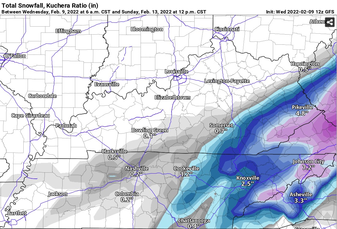
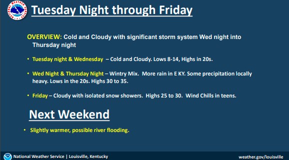
Now after those 2 waves pass through (by Tuesday morning), there is another system that should arrive by Wednesday evening into Thursday. Uncertainty remains for this system since we are still a way out, but models and data will continued to be monitored, to provide you with the updates they show. 


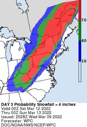
Screenshots of those model images will also be shared to show you what to expect around what timeframe. 


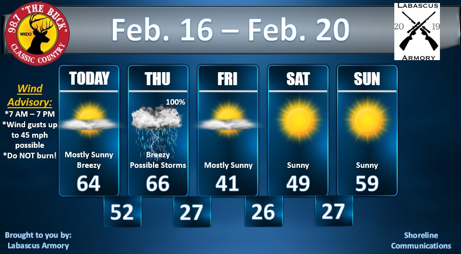
Below is a look at the extended forecast from today into Tuesday night, don’t want to share too far out with these waves as there will more than likely be a change in high temperatures compared to what is currently showing: 


Today – Mostly Cloudy; Highs in the mid to upper 30s 

Tonight – 20% Rain; Mostly Cloudy; Lows in the upper 20s. 


Saturday – 30% Freezing Rain/Rain; Mostly Cloudy; Highs in the mid 30s. 

Saturday Night – Cloudy; Lows in the low to mid 20s. 


Sunday – 20% Sleet; Mostly Cloudy; Highs in the low 30s.  

Sunday Night – 60% Freezing Rain/Sleet; Mostly Cloudy; Lows in the mid teens. 


Monday – 60% AM Sleet/Freezing Rain > Snow/Freezing Rain; Cloudy; Highs in the mid 20s. 

Monday Night – 80% Snow Showers/Freezing Rain > All Snow; Lows in the mid to upper teens. 


Tuesday – 20% Snow; Mostly Cloudy; Highs in the upper 20s. 

Tuesday Night – Mostly Cloudy; Lows in the mid to upper teens. 


Again, this forecast is subject to change, & we will provide those latest changes when possible.  


On another note, if you have a new business or an existing business and would like to sponsor these weather blogs, let us know! A great thing with these blogs is that they reach thousands & thousands of people, which in return would mean those people would see your business as well. Whether its on our website, on-air mentions, & on social media. We will get you set up, just send us an email and let us know at thebuck@chasingthebuck.com.


We are working on more great things to expand our weather updates, to become live more and even take live looks at local areas.

Monday February 8, 2021 - WINTER STORM WATCH

A Winter Storm Watch has been issued to take effect from late Tuesday night through Thursday.


A lot of people are questioning if this evening will be like 2009 & per NWS, this event will NOT be like the 2009 event or even the 2003 event that occurred in Lexington.


•Potential for ice accumulation ranges from 0.10 up to 0.75, with locally higher amounts possible. Snow & sleet accumulations of 1-2” will be possible North of I-64.


•TIMING: Waves of wintry precipitation will be possible late Tuesday – Thursday mainly across Southern Indiana & Central Kentucky. Area of freezing rain is likely, with SNOW to the NORTH and RAIN to the SOUTH. Majority of the chance of our precipitation locally will be from Wednesday night into Thursday.


•LOCAL AMOUNTS –

Ice amounts for the local area here in Casey, Taylor, & Lincoln (as of now) are forecasted at 0.10 up to 0.25, with locally higher amounts possible.


Counties such as Russell, Adair, & Pulaski are forecasted at showing ice accumulations of 0.01 to 0.10.


Counties north of our local area including Boyle, Washington, Jessamine, Fayette, & Hardin are forecasted at showing ice accumulations between 0.25 to 0.50.


If this line shifts South, there will be a sharp gradient, meaning that counties such as Green, Taylor, Casey, & Lincoln counties could see the northern parts receiving more accumulations (snow & ice) compared to the southern parts of the county (where they would not receive much accumulation).


•THREATS:

Snow Accumulations – Medium

Ice Accumulations – High

Winter Storm Timing – Medium/High

Winter Storm Impacts – High


•WHERE: As of right now, the main threat of counties to receive more ice will be north of Taylor & Casey counties. This line could be moved south depending on the trends of data/models. Bluegrass Parkway & North of I-64 is currently in the main line of this event.


•Possibility of Winter Storm Warning or even an Ice Storm Warning could be issued for parts of the state, more than likely will include Northern Kentucky, North Central Kentucky, & Central Kentucky.


•Just an informational fact, ¼” or more of ice, can damage trees & power lines.


•Another conference call will be held tomorrow, until then we will keep an eye on data & models for anymore updates in regards to this system pushing South as mentioned above.


***This forecast has been constantly changing and more than likely will continue to do so, I will keep a close eye on these models and the data trends & update as needed.


-Crystal

crystal@shorelinestations.com

Sunday February 7, 2021

Good Sunday evening, I hope everyone is having a great weekend as it winds down. Just wanted to share another weather update with you guys because compared to my last blog, models & data has changed so I want to keep you all up to date with the latest weather trends and forecasts as we go into this new week,


First things first, the big weather story for this week is about ice. The latest data and model trends are now leaning towards no major ice accumulations locally here in South Central KY as they were last week. We do still have just a slight chance of seeing around 1/10" of ice depending how this system comes through this week, Now folks to our North in the Ohio River Valley vicinity could definitely see ice headed their way. More than likely for our local area, any precipitation that we see from mid week til Thursday will be rain, it will just be too warm for anything else.


The second weather story I am watching for the latter part of the week into this coming weekend will be below freezing temperatures - high temperatures & low temperatures both.


We will "enjoy" high temperatures this week ranging from the low to upper 40s, almost at 50 a few days then by Friday, those high temperatures will top in the low to mid 30s. Low temperatures this week will range from low to mid 30s through Wednesday night, by Thursday night lows will be in the mid 20s.


Let's take an extended and detailed look at your forecast for this week even into your week so you can see the trend I am talking about.:


Tonight - Mostly Clear; Lows in the low 20s.


Monday - Mostly Sunny; Highs in the upper 40s.

Monday Night - 20% Showers; Mostly Cloudy; Lows in the mid 30s.


Tuesday - Mostly Cloudy; Highs in the upper 40s.

Tuesday Night - 30% Showers; Mostly Cloudy; Lows in the mid 30s.


Wednesday - 50% Showers; Cloudy; Highs in the upper 40s.

Wednesday Night - 80% Showers; Cloudy; Lows in the mid 30s


Thursday - 90% Showers; Cloudy; Highs in the upper 30s to low 40s

Thursday Night - 50% Showers (possible freezing rain); Cloudy; Lows in the mid 20s.


Friday - AM Chance of possible freezing rain; Mostly Cloudy; Highs in the mid 30s

Friday Night - Mostly Cloudy; Lows in the mid teens.


Saturday - 20% Snow showers/freezing rain; Mostly Cloudy; Highs in the low 30s.

Saturday Night - 20% Snow showers/freezing rain; Mostly Cloudy; Lows in the low teens.


Sunday - Partly Sunny; Highs in the mid to upper 20s


So as you can see by the latter part of the week, we will be dealing with colder weather which will last numerous days in a row for high temps and low temps.


This forecast continues to change daily and I will continue to keep an eye on model and data trends as well as the forecast and update with any major changes that we can expect.


PLEASE do not believe the hype of those who are sharing/telling that this is going to be a major ice storm or that there are multiple inches of snow forecasted because that is not true!


I do my best to pass on the most reliable weather information that I can not only here but on-air & also to our Facebook page and even my personal Facebook page.


I will update you guys as needed!


-Crystal

crystal@shorelinestations.com


Friday February 5, 2021

Good Friday evening everybody! Let’s get straight to the topic of this blog which is about the good ole Kentucky weather.


So short term it looks to be a calm weekend. As the saying goes “calm before the storm”. I think that is a good saying to use for what I am watching to unfold for our next week’s forecast.


Weekend looks calm for the most part but as we head into next week, especially Tuesday evening, I am keeping an eye on a system that will push through and deliver some arctic air to the region & we even have the chance to see a threat of freezing rain causing some icing issues. I will be watching models & forecast closely as these will be changing more frequently until this time comes. With multiple changes with the forecasts, that means things aren’t 100% set in stone when it comes to who will get what and where and how much. If there are major changes, I will be sure to post a blog to keep you guys updated.


I don’t want to get too far ahead of myself when it comes to the weather systems especially 6-7 days out due to all the data changing, but I will give you a heads up we could possibly continue to see this colder weather last & even have the chance of seeing some accumulating snowfall. How much? I have no idea as of right now but once data starts coming together better, I will give you another heads up.


Let’s go ahead and take a look at your weekend forecast & your extended forecast into the latter part of next week as well below:


Tonight – Increasing clouds; Lows in the upper 20s.


Saturday – Mostly Cloudy; Highs in the mid-40s.

Saturday Night – Mostly Cloudy; 50% Rain > Rain/Snow > Snow; Lows in the mid to upper 20s.


Sunday – AM Clouds > Afternoon Sunshine; Highs in the upper 30s.

Sunday Night – Partly Cloudy; Lows in the low 20s.


Monday – Mostly Sunny; Highs in the mid to upper 40s.

Monday Night – 30% Showers; Mostly Cloudy; Lows in the mid-30s.


Tuesday – 40% Showers; Mostly Cloudy; Highs in the low to mid 40s.

Tuesday Night – 30% Rain/Snow; Mostly Cloudy; Lows in the low to mid 20s.


Wednesday – Mostly Cloudy; Highs in the low to mid 30s.

Wednesday Night – Mostly Cloudy; Lows in the upper teens to low 20s.


Thursday – 20% Snow showers; Mostly Cloudy; Highs around 30.

Thursday Night – 30% Snow Showers; Mostly Cloudy; Lows in the low teens.


Friday – 20% Snow showers; Partly Sunny; Highs in the low 20s.


I usually don’t share the extended forecast as far out as I have done, but I just want you guys to see how cold it will be for the highs come Friday. **As always the forecast is subject to change and when it does I will do my best to update you all here & on-air on 98.7.**


That’s all for now, I hope you guys have a great weekend!


-Crystal

crystal@shorelinestations.com

Tuesday February 2, 2021

Happy February! I hope everyone has been well & for those of you who wanted it, I hope you enjoyed the little bit of snow we received at the end of your weekend! I wanted to make this update today and give you guys a heads up about a plunge in high temperatures as we enter next week.


We will see a bit of a warm up as your week goes on into this weekend then by Sunday night high temperatures will be in the low 30s and Sunday night low temperatures could hit down in the single digits.


We also have another chance of seeing some flurries as well, lets take a look at your detailed forecast below:


Tonight: Increasing Clouds; Lows in the mid-20s.


Wednesday: Mostly Sunny; Highs in the upper 30s.

Wednesday Night: Increasing Clouds; Lows in the low to mid 20s.


Thursday: 30% Afternoon Showers; Mostly Cloudy; Highs in the mid to upper 40s.

Thursday Night: 100% Rain > Rain/Snow (Less than 1/2" possible); Cloudy & Breezy (wind gusts up to 29 mph); Lows in the upper 20s.


Friday: 60% AM Flurries; Mostly Sunny; Highs in the upper 30s.

Friday Night: Mostly Clear; Lows in the low to mid 20s.


Saturday: Mostly Sunny; Highs in the low to mid 40s.

Saturday Night: 40% Rain/Snow; Mostly Cloudy; Lows in the low 20s.


Sunday: 30% Snow Showers; Partly Sunny; Highs in the low to mid 30s.

Sunday Night: Partly Cloudy; Lows in the upper single digits.


Monday: Mostly Sunny; Highs in the low 30s.


**Keep in mind the forecast is subject to change & when it does, we will be sure to pass along the most up to date information.**


I will continue to keep an eye on the forecast & update if there are any major changes. Stay warm & stay safe until next time folks!


-Crystal

crystal@shorelinestations.com

UPDATE: Tuesday January 26, 2021

Good evening, I know it is late (11:45 PM) but just wanted to give a quick update in regards to our weather for tomorrow.


Per my prior blog from earlier today, our local area will be under a Winter Weather Advisory now effective at 3 PM EST, which is an hour earlier than when it was first issued to take effect at 4 PM EST Wednesday.


A Winter Weather Advisory means that wintry weather is expected. Be sure to exercise caution as slick and hazardous conditions are possible for development.


As models update, it looks like there could also be a change in forecasted sno accumulations as well. Locally we could get up to a possible 1/2", for other areas that was in that same forecasted snow total, they could possibly see up to 1".


I will continue to monitor model & update as needed tomorrow. As for this Tuesday, I am calling it a night but be sure to keep an eye out for a new blog tomorrow & we will have live weather coverage on-air at 98.7, online at chasinthebuck.com or via the Simple Radio app that you can download for your mobile device!


-Crystal

crystal@shorelinestations.com

Tuesday January 26, 2021

We go from storms on Monday to sunshine & spring-like weather today for your Tuesday, then for Wednesday evenig/night snow showers. Just by all this, you know you're in Kentucky.


Let's get to talking about what to expect over the next 24-48 hours & take a look at your forecast as we head into your weekend.


With a wind shift, cold air will move into place tonight across the state. We will see the best chance of rain, rain/snow, & snow by sunset Wednesday into the overnight hours and into the early morning hours Thursday. As of now, it stands that how much snow you'll see, depends where you are. East of I-65 will have some impacts to travel for Wednesday evening. Locally we are forecast to see up to a possible 1/2", other areas could see up to 1". Once this system moves out of the state Wednesday night, we will have some cold temperatures as Thursdays highs will hang around the low to mid 30s.


A Winter Weather Advisory (for South Central/Northern counties above) has been issued & will take effect from 4 PM Wednesday into 1 AM Thursday morning. Total snow accumulations of up to 1" are possible during the evening commute. This will affect areas generally along & East of I-65 & North of a line from Elizabethtown to Liberty.


A Winter Weather Advisory (for Eastern counties above) has been issued & will take effect from  4 PM Wednesday to 3 AM Thursday morning. Total snow accumulations for this area of up to 1" are possible during the evening commute. 


Let's take a look at your detailed forecast from Wednesday into the weekend below:


Wednesday - 70% Rain; Mostly Cloudy; Highs in the low 40s. *Winter Weather Advisory takes effect 4 PM*
Wednesday Night - 60% Rain-Rain/Snow-Snow; Mostly Cloudy; Lows in the low 20s; New snow accumulation of up to s possible 1/2" locally.


Thursday - Sunny; Highs in the mid 30s. *Winter Weather Advisory expires 1 AM*
Thursday Night - Mostly Clear; Lows around 20.


Friday - Sunny; Highs in the low to mid 40s.
Friday Night - Partly Cloudy; Lows in the mid 20s.


Saturday - 30% Showers; Mostly Cloudy; Highs in the upper 40s.
Saturday Night - 80% Showers; Lows in the upper 30s, around 40.


Sunday - 30% Showers; Mostly Cloudy; Highs in the low 50s.
Sunday Night - 20% Rain/Snow; Mostly Cloudy; Lows in the low 30s.


Keep an eye for new blogs to be posted if there are any major changes with this system. 


-Crystal

crystal@shorelinestations.com

On Air Now

Jerry Atwood
Jerry Atwood
6:00am - 9:00am
Buck Morning Show

CNN News

Entertainment News

Twitter