.jpg)
First off, I want to give a huge THANK YOU, to all of our line men & women, county road crew, state road crew, healthcare workers, essential workers, & anyone else who has to be out in this weather. For you guys and gals, we are truly thankful & appreciative! Prayers for your safety! A friendly little note, to help your mail carriers out, be safe while doing so, but try and knock off the ice on your mail box so they don't have to fight that battle. Also if you see any of these men & women out, pay it foward with a drink or meal, or even a Thank You, it goes a long way.
We have finally made it through this first winter system, now are you prepared for a second?
That’s what is on the table for late Wednesday night/early Thursday morning into late Thursday night/early Friday morning. Snow, sleet, freezing rain, & cold rain will all be on the table for this second system as it moves in late tomorrow night/early Thursday morning. Again just like with this winter storm from yesterday, uncertainty remains for which areas will receive what exact precipitation.
Expect a Winter Weather Advisory to be issued later on today for parts of the region.
Locally we are forecasted to receive 2-4” of additional snowfall on top of what we have already received this week. Below I have posted a couple of models with “predicted” snowfall totals, the NAM & GFS models. (These are just to show the difference, as we all have seen, from the start of the talk of the last storm until it got here, ALL forecasts from weather folks (including myself) even NWS was off. Winter weather stinks because of this.)
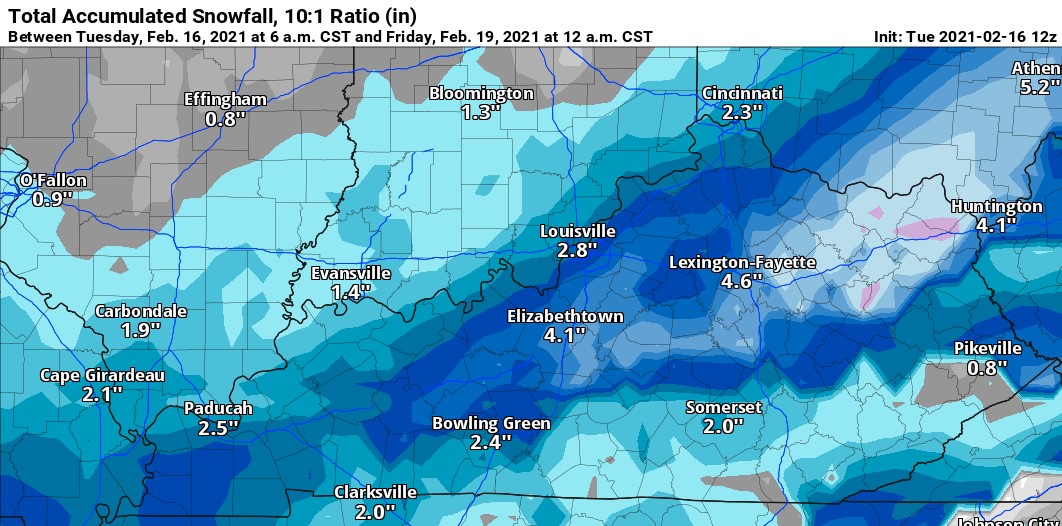
This is a look at the GFS Model through Friday at midnight.
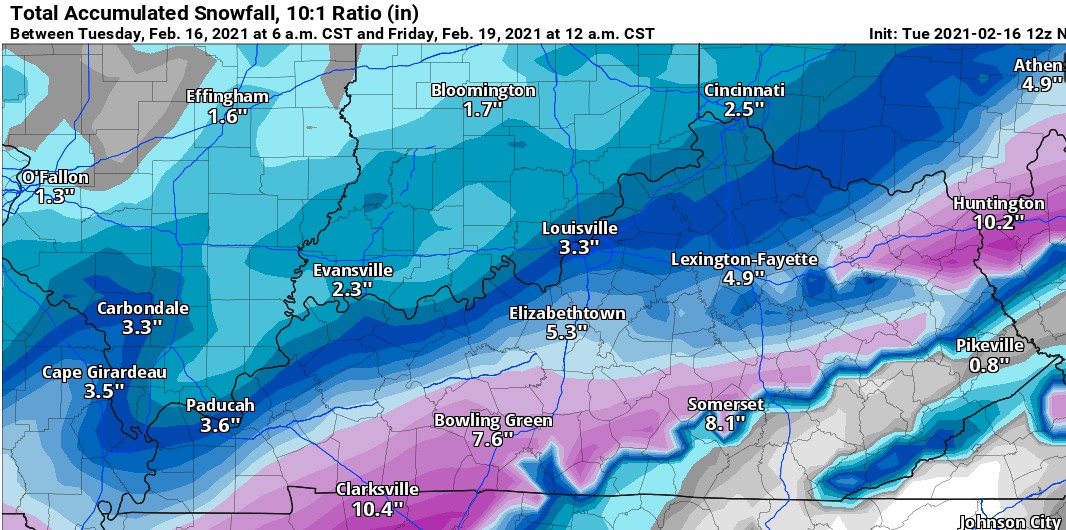
This is a look at NAM model through Friday at midnight.
Also here is a look at a couple of updated briefing slides from the NWS:
.jpg)
.jpg)
As you can tell, there is quiet a bit of difference between the NAM & GFS models when it comes to snow totals. Again ideally, a range of 2-4" is more realistic for our area especially since we will be dealing with warmer temperatures.
Let's take a look at the detailed/extended forecast into this weekend:
Today - Flurries; Mostly Cloudy - Partly Sunny; Highs in the low 20s with wind chill values around 4.
Tonight - Mostly Cloudy; Lows around 10 with wind chill values around 0.
Wednesday - 30% Afternoon Snow Showers; Mostly Cloudy; Highs in the low 30s.
Wednesday Night - 90% Snow/Freezing Rain; Mostly Cloudy; Lows in the mid to upper 20s. New snow totals of 2-4" possible.
Thursday - 90% Freezing Rain/Snow/Rain; Cloudy; Highs in the low to mid 30s.
Thursday Night - 50% Snow Showers; Cloudy; Lows in the mid to upper teens.
Friday - Mostly Cloudy & Cold; Highs in the mid 20s.
Friday Night - Mostly Cloudy; Lows in the single digits.
Saturday - Mostly Sunny; Highs in the low to mid 30s.
Saturday Night - Partly Cloudy; Lows around 20.
Sunday - Mostly Sunny; Highs in the low 40s.
Again, this forecast will change & I will provide updates the best that I can on-air, on our Facebook page ( https://www.facebook.com/Classic-Country-987-The-Buck-WKDO-610411902307145 ). If you have any questions, comments, or concerns, you're more than welcome to send me an email & I will answer and help out the best that I can.
-Crystal
crystal@shorelinestations.com