Join Jerry from 6:00 AM to 1:00 PM every Monday-Friday morning. Join Crystal from 1:00 pm to 6:00 pm every Monday-Friday afternoon!
Welcome to CHASINTHEBUCK.COM

Forgot Password

Not a Member? Sign up here!

banner
banner
banner
banner
banner
banner

Weather Archives for 2022-02

A break in the rain ends tonight, Flood Watch issued. Brought to you by The Labascus Armory

98.7 The Buck's Weather Blog is brought to you by The Labascus Armory, check them out today on Facebook & their website at labascusarmory.com.


Today was a bit cooler with high temps only reaching in the upper 30s across much of the area, which was lower than originally forecasted from the mid to upper 40s. Not only did we deal with cooler temps today but we also dealt with a break from the rain but it won't last long as showers return to the forecast tonight as well as a new Flood Watch, details are below:


As stated above, we were able to enjoy a break in the precipitation today as the area was situated between the cold front that pushed through as well as an area of canadian high pressure.

Tonight, precipitation kicks back in as rain chances remain between 90%-100%. This precipitation is due to being ahead of a large upper trough as it moves across the Ohio Valley.

Locally here in South Central Kentucky we will see just rain. Central & Northern Kentucky could get a slight taste of a wintry mix including some light icy precipitation (freezing rain, sleet, snow).

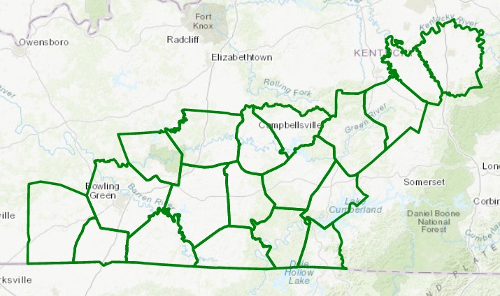
Looking ahead into Thursday, Thursday night, & Friday, a Flood Watch has been issued and will be effective starting at Midnight EST Thursday 2/24 through 7 AM EST Friday 2/25. Please see the graphic below for the counties included in this watch:


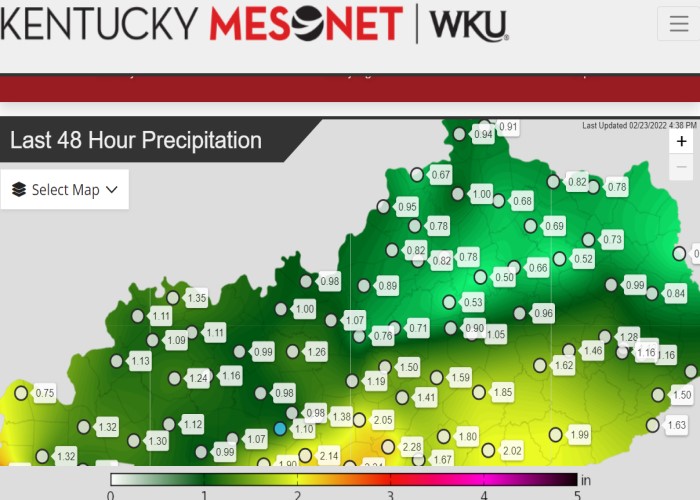
Adding additional rainfall on top of the rain we have received over the last 48 hours has the potential for some localized flooding. See below the latest rainfall totals per the Kentucky Mesonet site over the last 48 hours:


Once we get past this wet weather, we will see a drier forecast for the weekend into next week before a slight chance of showers shows up in the forecast again. Below is a short overview of what to expect:

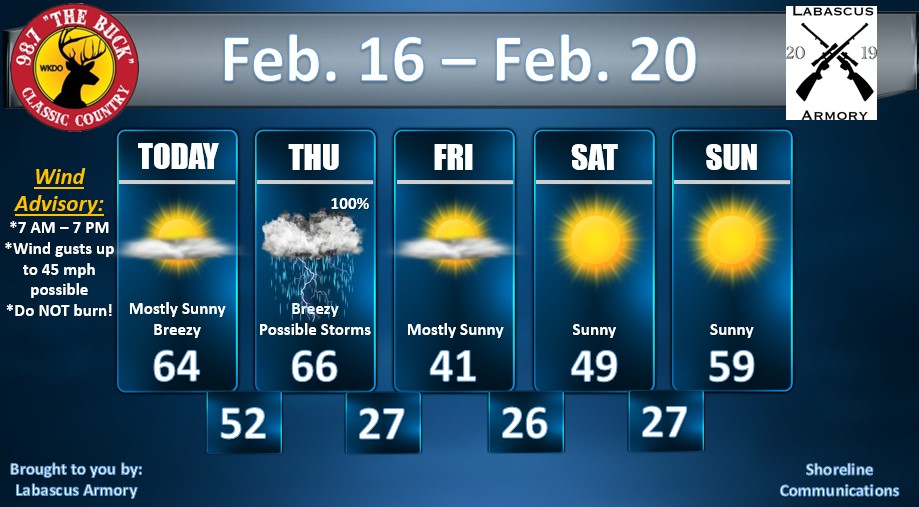
Tonight - 90% Showers - Lows in the mid 30s.

Thursday - Flood Watch in effect - 100% Showers - Highs in the mid 50s.

Thursday Night - Flood Watch remains - 100% Showers - Lows in the upper 30s.

Friday - Flood Watch expires at 7 AM EST - 100% AM Showers - Highs in the mid 40s.

Friday Night - Mostly Cloudy - Lows in the mid 20s.

Saturday - Partly Sunny - Highs in the mid 40s.

Saturday Night - Mostly Cloudy - Lows in the upper 20s.

Sunday - Mostly Sunny - Highs in the upper 40s.

Sunday Night - Mostly Clear - Lows in the mid 20s.

Monday - Sunny - Highs in the mid 40s.

Monday Night - Mostly Clear - Lows in the mid to upper 20s.

Next chance of showers will be Tuesday night currently showing at 20%.


Keep in mind the forecast is subject to change and when it does I will be sure to update you on 98.7.


-Crystal

crystal@shorelinestations.com

Wind, Showers, Storms, Oh My! - Sponsored by The Labascus Armory - 2/16/22

98.7 The Buck's Weather Blog is brought to you by The Labascus Armory, check them out today on Facebook & their website at labascusarmory.com.


Good Tuesday night folks! Enjoy the spring-like & breezy conditions while they last because we have showers, storms, & colder temperatures on the way. Heres the rundown:


A Wind Advisory will be effective from 7 AM - 7 PM EST Wednesday February 16th for our area. Wind gusts up to 45 mph will be expected. In return this could cause possible power outages as well as tree limbs being blown in the road way. Use caution if you drive a high profile vehicle as well.


The possibility remains for that Wind Advisory to carry over into Thursday, or it will be upgraded to a High Wind Watch or Warning. Ill keep an eye on that.


Thursday, we have showers & storms in the forecast for our area. As this system pushes through, some areas could see 1" up to 2" of rain. Locally I would forecast up to 0.75". The increased rain amounts would be to our South West. I will continue to monitor this as well.


Once this system pushes through, we will go from mid 60s Thursday afternoon down to the mid 20s overnight into Friday morning as your lows. Friday high temps only near 40. But the good thing about this is by Sunday we will be back around 60 degrees so the colder temps won't last long.


Weekend weather forecast looks great with plenty of sunshine, below is a look at the forecast:


I will continue to monitor & update as needed as always on 98.7. As always feel free to email me anytime with any questions you may have. Depending on the changes, keep an eye out on our Facebook page for live weather updates via video!


-Crystal

crystal@shorelinestations.com

Warmer Temps Won't Last This Weekend - Brought to you by The Labascus Armory

98.7 The Buck's Weather Blog is brought to you by The Labascus Armory, check them out today on Facebook & their website at labascusarmory.com.


Good mid-week Wednesday folks! It has been calm this week in the weather world. Mild temperatures & plenty of sunshine is the perfect forecast compared to what we have dealt with in the last few weeks.


Don't get too spoiled to the mild temps tho because a cold front will make its way across the area this weekend. Friday's high temps will top around 60 & by Sunday, high temps will be around the mid-30s. Oh & might I mention, we have the potential for a light snow event this weekend, let me give you the rundown.


So I will be showing you the NAM & GFS models in this blog (yes there are many others but I am just choosing 2 to keep it simple).

Above is the NAM model that shows forecast snow totals through 7 PM EST Saturday evening. As you can see some local areas are showing little to nothing. As we look into Russell, Pulaski, & counties South, there is a bit of accumulation of around 1', give or take. Now let's take a look at the GFS model below:


All of you who are not as much of a snow lover as others, depending on where you live, might like the GFS a bit better. This GFS screenshot is good through Sunday at 1 PM EST. Snow accumulations are lesser at less than 1" for our local area.


All in all even tho the accumulations are showing different on each model, the one things these models have in common is the POTENTIAL for a light snow event.


I will continue to monitor data & model trends and keep you updated. You can catch your updates on air on 98.7, here on our website, & even on Facebook (be sure to like & follow us). Until the next time, enjoy the sun & mild temps!


Crystal

crystal@shorelinestations.com

11 PM Update for Flooding Potential & Winter Storm - Brought to you by the Labascus Armory

11:00 PM Weather Update is sponsored by The Labascus Armory.


Good Tuesday evening. We had some beautiful weather earlier today, I hope you was able to get out & enjoy it because changes are on the way. The calm before the storm....... as they say.


Flooding Potential:

Let’s talk flooding potential first.

Rain chances will be low tonight into your early morning hours Wednesday, around 20-30% chance.  As we get into Wednesday, the surface cold front will push its way into parts of Kentucky. Rain chances increase to 90-100% & should be fairly consistent throughout the day. NWS Louisville is forecasting rain totals from 2.5” to 3.5” for some areas. This will in return cause excessive runoff which in return will cause some localized flooding. Rain will continue into Thursday as rain before transitioning over to freezing precipitation & snow (for parts of the state). I will be monitoring updates for the possibility of a Flood Watch being issued.


Winter Storm:

After our flooding potential, comes this winter storm I have been tracking. NWS has already issued a Winter Storm Watch to take effect from Thursday morning into Friday morning including counties in South Central, Central, Northern, & Northwestern Kentucky. As of now the farthest south that watch extends is in Pulaski County.

A surface cold front will slowly move into parts of the state overnight Wednesday & continue to push across into Thursday morning. Models depict a sharp surface temperature gradient with the front & precipitation will transition from rain to a mix of wintry precipitation (sleet/freezing rain/snow). The front will continue to push its way across the state into Thursday night when it will clear the region. Temperatures will be lucky to get at 32 degrees as the high on Friday, Friday night lows will be in the teens.


Timing of Precipitation Transition:

Timing is not set in stone even though models continue to update. The most recent trends are showing the cold front arriving faster than prior updates. If the cold front does indeed arrive faster, there will be a quicker transition from rain to wintry precip. The front could slow down as it moves across the region, which could cause increased freezing rain & sleet rates. Keep in mind most of the snow will stay to our North/Northwest. Areas between the Bluegrass/Western Kentucky Parkway and areas from the parkway to I-64 could see a spike in the freezing precip. After all this, the front will work its way out of the region early Friday morning.


Precipitation Types & Where:

Latest model runs (GFS & NAM) are showing a bit of a difference in who gets ice and who gets rain LOCALLY. Again most of the snow precipitation will be to our North and northwest.

Last run shows the GFS model depicting ice & rain for our local area. The NAM model depicts us getting less ice and more rain. If this system moves and goes more towards the GFS model, ice totals could be up to ½” for some places.


Preparedness:

I am not saying this to cause hype or to make this system out worse than what it will be, but be safe than sorry folks.

Now is the time to get what you need from the grocery store (don’t be hoggish), get needed medications, generators, source of heat, update your emergency kits, make travel reservations as travel will be impacted for certain Thursday night into Friday. Just use common sense. Be sure to keep your mobile phones charged, have fuel in your vehicles, a source to receive the latest weather updates, etc.


Final Thoughts:

I will continue to pass along updates as they come in. NWS will be holding not one but TWO conference calls tomorrow, so I will be sure to pass along the latest information here.


Also keep in mind, models have been going back and forth, like a game of tennis, in where exactly this line of ice will hit. These models WILL continue to change up until the day of this event. Winter weather is harder to follow & forecast compared to your thunderstorms.


Don’t forget to listen for weather updates on-air on 98.7 on your radio dial. You can also listen off of the free app Simple Radio and here on our website chasinthebuck.com. Of course if you’re big on social media following pages, be sure to follow us on there as well Classic Country 98.7 The Buck “WKDO”.


If you have any additional questions feel free to email me at crystal@shorelinestations.com


-Crystal

Flooding & Winter Storm Update - Brought to you by The Labascus Armory

12:40 AM Weather Update:
Sponsored by The Labascus Armory

Flooding & Freezing Rain Potential

Model data shows some agreeance to an extent, as the latest updates come through tonight. Let’s take a look at timing, what to expect precipitation wise, & what questions are still left unanswered as of tonight.

TIMING:
Slight rain chances will make their way into the forecast Tuesday night, currently showing about 30-40% chance locally.

Rain chances increase Wednesday to 90-100% & will remain that way through Thursday. This will cause some flooding issues for some areas. Rain totals of 2.75”-3” are expected across the area.

Thursday will be the big day of change as this system pushes through with the arctic air behind it. Temperatures may start out fairly warm but will drop significantly as the day progresses. The transition of rain to freezing rain/sleet looks to take place throughout the afternoon into the evening. As the evening and night progresses precipitation will transition to all freezing rain, into the early morning hours on Friday.

PRECIPITATION:
Locally, we will definitely rain/freezing rain/ sleet. If we see snow it will be light. Our neighbors to our North on the other hand, has a better chance of snow compared to us.

UNCERTAINTIES:
Just a reminder, agreeance with models will get better the closer we get to this system, especially about 24-36 hours out.

As of tonight, questions that remain unanswered are:
1) How much precipitation will we get?
2)Which type of precipitation will remain fairly dominant for our local area?
3)How fast will this arctic air move?
4)How far South will this arctic air go?

Hopefully tomorrow I can have answers to the questions above.

FINAL THOUGHT:
This will be an impactful winter event, so prepare now if you can. If you need items, get them (do not be hoggish).
Always remember, rather be safe than sorry.

I’ll continue to monitor and keep updates posted as needed.


Contact me:

crystal@shorelinestations.com


-Crystal