Join Jerry from 6:00 AM to 1:00 PM every Monday-Friday morning. Join Crystal from 1:00 pm to 6:00 pm every Monday-Friday afternoon!
Welcome to CHASINTHEBUCK.COM

Forgot Password

Not a Member? Sign up here!

banner
banner
banner
banner
banner
banner

Weather Archives for 2021-01

UPDATE: Tuesday January 26, 2021

Good evening, I know it is late (11:45 PM) but just wanted to give a quick update in regards to our weather for tomorrow.


Per my prior blog from earlier today, our local area will be under a Winter Weather Advisory now effective at 3 PM EST, which is an hour earlier than when it was first issued to take effect at 4 PM EST Wednesday.


A Winter Weather Advisory means that wintry weather is expected. Be sure to exercise caution as slick and hazardous conditions are possible for development.


As models update, it looks like there could also be a change in forecasted sno accumulations as well. Locally we could get up to a possible 1/2", for other areas that was in that same forecasted snow total, they could possibly see up to 1".


I will continue to monitor model & update as needed tomorrow. As for this Tuesday, I am calling it a night but be sure to keep an eye out for a new blog tomorrow & we will have live weather coverage on-air at 98.7, online at chasinthebuck.com or via the Simple Radio app that you can download for your mobile device!


-Crystal

crystal@shorelinestations.com

Tuesday January 26, 2021

We go from storms on Monday to sunshine & spring-like weather today for your Tuesday, then for Wednesday evenig/night snow showers. Just by all this, you know you're in Kentucky.


Let's get to talking about what to expect over the next 24-48 hours & take a look at your forecast as we head into your weekend.


With a wind shift, cold air will move into place tonight across the state. We will see the best chance of rain, rain/snow, & snow by sunset Wednesday into the overnight hours and into the early morning hours Thursday. As of now, it stands that how much snow you'll see, depends where you are. East of I-65 will have some impacts to travel for Wednesday evening. Locally we are forecast to see up to a possible 1/2", other areas could see up to 1". Once this system moves out of the state Wednesday night, we will have some cold temperatures as Thursdays highs will hang around the low to mid 30s.


A Winter Weather Advisory (for South Central/Northern counties above) has been issued & will take effect from 4 PM Wednesday into 1 AM Thursday morning. Total snow accumulations of up to 1" are possible during the evening commute. This will affect areas generally along & East of I-65 & North of a line from Elizabethtown to Liberty.


A Winter Weather Advisory (for Eastern counties above) has been issued & will take effect from  4 PM Wednesday to 3 AM Thursday morning. Total snow accumulations for this area of up to 1" are possible during the evening commute. 


Let's take a look at your detailed forecast from Wednesday into the weekend below:


Wednesday - 70% Rain; Mostly Cloudy; Highs in the low 40s. *Winter Weather Advisory takes effect 4 PM*
Wednesday Night - 60% Rain-Rain/Snow-Snow; Mostly Cloudy; Lows in the low 20s; New snow accumulation of up to s possible 1/2" locally.


Thursday - Sunny; Highs in the mid 30s. *Winter Weather Advisory expires 1 AM*
Thursday Night - Mostly Clear; Lows around 20.


Friday - Sunny; Highs in the low to mid 40s.
Friday Night - Partly Cloudy; Lows in the mid 20s.


Saturday - 30% Showers; Mostly Cloudy; Highs in the upper 40s.
Saturday Night - 80% Showers; Lows in the upper 30s, around 40.


Sunday - 30% Showers; Mostly Cloudy; Highs in the low 50s.
Sunday Night - 20% Rain/Snow; Mostly Cloudy; Lows in the low 30s.


Keep an eye for new blogs to be posted if there are any major changes with this system. 


-Crystal

crystal@shorelinestations.com

SUNDAY JANUARY 24, 2021

Good Sunday evening, I hope you have had and are continuing to have a great weekend. I do have some weather information to pass along to you to keep you on top of what we will be seeing over the next 24 hours for our local area, so let’s get started.


Some parts of the local area have seen some rain today, nothing major though. As your evening and night goes on into tomorrow, rain chances will be at 100% and rain totals will average any where between 1” to 2”. These will be widespread rain showers that we will be seeing, some of which could be heavy at times therefore causing some localized flash flooding. The SPC has already placed parts of our local area back Westward, under a MARGINAL (see graphic below to category definition) risk for thunderstorms as well. Yes, I said thunderstorms, here in January. It’s Kentucky what do you expect?


     *******************************************************************************************************


SPC Products


As the warm front pushes through, that means moderate to occasional heavy rain will move northward and into South Central Kentucky later on tonight. Monday will be our all-day rain event, as I stated above, with rain totals averaging from 1-2”. Current models are showing that the heaviest rain showers could drop around 1 inch of rain in 3 hours. In regards to Flash Flood Watches/Warnings being issued, that amount of rain still falls short of the guidance that is needed to have those issued. We cannot rule out having a Flash Flood Watch issued as models update & as this system pushes through tomorrow.


May be an image of map, sky and text that says 'Rainfall Forecast Tonight Monday Night Weather Forecast Office Louisville KY Issued Jan 24, 2021 3:05 PM EST 1151 Covington 1-1.5" Madison 1-1.5" asper Louisville Owensboro Morehead Elizabethtown Paducah Campbelisville Jackson 1.5-2" 1.5-2" Bowling Gréen Hopkinsville London Albany Precipitation NWSLouisville weather.gov/lmk'


Now when it comes to temperatures for your Monday afternoon, you may be pleasantly surprised as we will have high temperatures around the upper 50s - lower 60s for most of the area. Monday night low temperatures will be around 40 degrees with the continued rain chance, just decreased.


Extended Forecast:


Monday night rain chances decrease and rain will push out of the area. By Tuesday we will see clear & sunny skies with high temperatures in the upper 50s along with a slight breeze (7-10 mph). Our next rain chance will be on Wednesday currently showing a 40% with Partly Sunny skies, highs in the upper 40s-50 degrees. Rain chances will continue into Wednesday night, a slight increase in the chance, low temperatures will have a drop into the mid 20s. By the weekend, we could see a warm up with high temperatures back in the 50 degree range.


I will post another blog tomorrow as time allows and also if there are any flooding issues within our local area.


-Crystal

crystal@shorelinestations.com

UPDATE: Friday January 15, 2021

3:45 PM Weather Update:


Here is the latest update in regards to our wintry weather for tonight into tomorrow morning:


Note: A Winter Weather Advisory remains to take effect at 9 PM tonight and last through tomorrow at 1 PM.


Some areas have already started to see some rain/snow this afternoon, even though it was short lived. As your evening and night goes on we can’t rule out experiencing some thundersnow (basically hearing some thunder along with the snow showers). Chances are low but at the same time its still a possibility to occur.


Overnight & into the early morning hours will be the best chance of seeing precipitation on the ground. Traffic could be impacted during this time so be sure to use caution if having to travel, even though surface temperatures will be fairly warm considering.


As Saturday goes on, snow showers will be intermittent & highs will only be around the upper 30s. From the NWS forecast discussion, they state that overall snow amounts could exceed an inch by Monday morning for several locations across the state, a lot of the snow though will occur in spurts and likely melt down some before the next wave of snow showers move in.


The Easter Bluegrass (I-75 corridor area), has the best potential to see accumulating snow and potential impacts, and can’t rule out future advisories being issued.


Drier weather will return for the most part come next week. But we will have the chance of seeing rain & possibly some snow flurries by end of week next week.


I’ll update again if there are any major changes.

Friday January 15, 2021

***New Weather Blog has been posted with updates as of 3:45 PM***Check it out***


Good Friday afternoon, as promised here is an updated blog since the forecast has changed for our area since yesterday’s blog that was posted. 


Let’s start off by talking about what NWS is sharing in regards to our local area and snow chances & accumulation.  


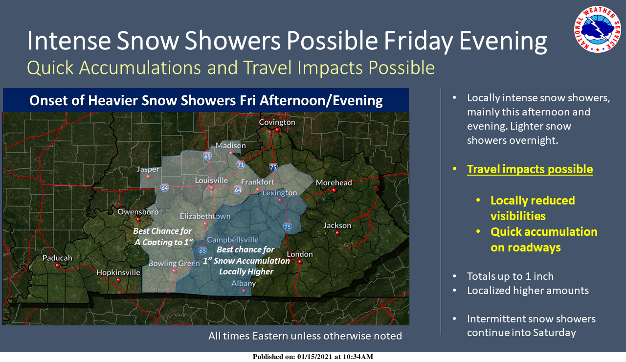
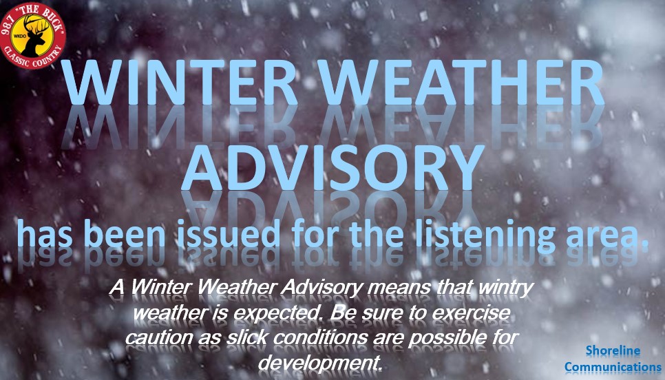
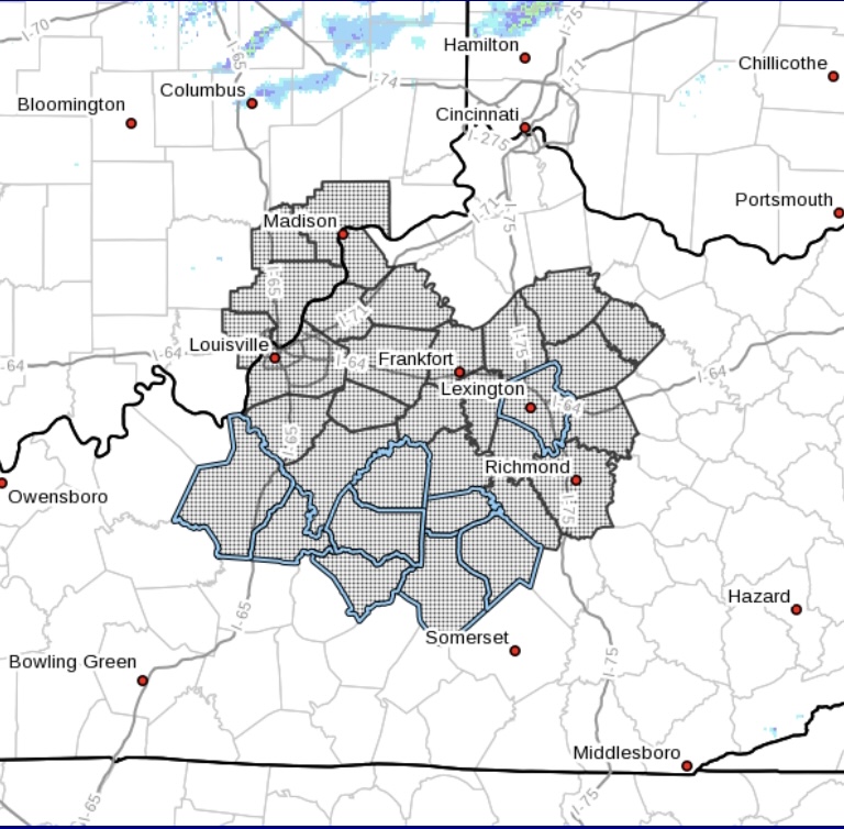
A Winter Weather Advisory will be in effect from 9 PM EST tonight through 1 PM tomorrow afternoon for our local area including the counties of Adair, Boyle, Casey, Green, Lincoln, Marion, Russell, & Taylor. For this advisory, snow is expected & some snow accumulations up to 1” are possible, with some isolated areas seeing a possible accumulation of up to 2”. 


Today – Tonight: 

Continuing to look at the weather for the above mentioned counties, for this evening into the overnight hours, scattered/intense snow showers will continue to develop resulting in light accumulations. Even though surface temperatures are above freezing, we can’t rule out seeing a few slick spots. The development of snow showers will continue into the early hours tomorrow morning with accumulations resulting anywhere from a dusting up to 1”, & a possible 2” in isolated areas. 


Saturday into next week: 

As we move into the weekend, we can expect additional periodic snow showers late Saturday afternoon into Sunday night. Additional light snow accumulations can’t be ruled out, as well as negative travel impacts since surface temperatures will be on the decline & cause additional slick spots. 


This evening into the weekend: 

For our counties of Pulaski, McCreary, & Wayne, as of this afternoon there is no advisory that has been issued to be in effect. Showers will develop overnight tonight with light accumulations possible by sunrise tomorrow morning. For the remainder of the weekend, we can’t rule out seeing scattered snow showers which could lead to additional light accumulations. 


In regards to timing, you can see the image below that was issued by NWS Louisville from earlier this morning. I will continue to monitor updated forecast discussions, hazard weather outlooks, & special weather statements so I can continue to pass along the most up to date weather information to you here & on air this afternoon on 98.7. 


While I’m at it, here is an updated look at your short term forecast for the rest of the afternoon into Sunday: 


This Afternoon – 30% Rain/Snow Showers; Increasing Clouds; Breezy at times (wind gusts up to 24 mph); Highs in the low 40s. 

Tonight – 50% Rain/Snow Showers; Mostly Cloudy; Lows around 30; Snow accumulations of a dusting up to a possible 1” expected. 


Saturday – 50% Snow Showers; Mostly Cloudy; Breezy at times (wind gusts up to 21 mph); Highs in the upper 30s. New snow accumulation of less than 1” possible. 

Saturday Night – 20% Rain/Snow Showers; Cloudy; Lows around 30. 


Sunday – 30% Rain/Snow Showers; Mostly Cloudy; Highs in the upper 30s. 


The forecast & weather information in this blog is up to date as of 11:25 AM this Friday afternoon, 1/15/2021. 


I will continue to monitor & post updates as needed as the forecast changes. 


Thursday January 14, 2021

It has been a beautiful & warmer day across the local area, so I hope everyone was able to enjoy that because high temperatures will be on the decline & we also have the chance of seeing snow showers as we head into the weekend.


Starting off, a cold front will be moving across the state within the next 24 hours. A narrow corridor of light precipitation will develop & push East of the I-75 corridor in those early hours tomorrow morning. With having highs today in the low 50s, by Saturday we will have highs in the mid to upper 30s. Also within that time, we will have a chance of seeing some additional rain & snow showers.


Any snow that should develop tomorrw should be short-lived & shouldn't impact anything due to warm ground temperatures. Snow that develops late tomorrow afternoon for part of the state will be West of I-65.


For tonight, we do have a 70% chance of precipitation of which will be rain & that will occurr in the early morning hours for tomorrow. Below is a look at the detailed/extended forecast:


Tonight - 70% Rain; Mostly Cloudy; Breezy, wind gusts up to 20 mph; Lows in the low 30s.


Friday - 20% Rain/Snow Showers; Mostly Sunny; Highs in the low 40s.
Friday Night - 40% Snow Showers; Mostly Cloudy; Lows in the upper 20s.


Saturday - 40% Snow Showers; Mostly Cloudy; Highs in the upper 30s.
Saturday Night - 20% Rain/Snow Showers in the evening; Mostly Cloudy; Lows in the upper 20s.


Sunday - 30% Snow Showers; Mostly Cloudy; Highs in the upper 30s.
Sunday Night -20% Snow Showers; Mostly Cloudy; Lows in the mid 20s.


MLK Day - Monday - Partly Sunny; Highs in the upper 30s.
Monday Night - Partly Cloudy; Lows in the upper 20s.


Tuesday - Mostly Sunny; Highs in the mid 40s.
Tuesday Night -40% Rain/Snow Showers; Mostly Cloudy; Lows in the low 30s.


If there are any major changes with our snow chances or anything with the forecast, I will be sure to update with another blog. So far there are no snow accumulations forecasted.


***This forecast is current as of 4 PM, Thursday 1/14/2021***


Thanks for reading & sharing!


-Crystal
crystal@shorelinestations.com

Wednesday January 13, 2021

Good Wednesday evening! I hope everyone has had a great day & week so far! Just wanted to give a quick update since we do have just a slight chance of seeing some snow flurries towards the end of the week this week.


Here is a look at your extended/detailed forecast for tonight into the weekend:


Tonight - Partly Cloudy; Lows in the low 30s.


Thursday - Mostly Sunny; Highs in the low 50s
Thursday Night - 20% Showers; Mostly Cloudy; Lows in the low to mid 30s.


Friday - 20% Rain/Flurries; Partly Sunny; Highs in the low to mid 40s.
Friday Night - 30% Rain/Flurries; Mostly Cloudy; Lows in the upper 20s.


Saturday - 30% Rain/Snow; Mostly Cloudy; Highs in the upper 30s.
Saturday Night - 20% Showers; Mostly Cloudy; Lows in the mid to upper 20s.


Sunday - 20% Rain/Snow; Mostly Cloudy; Highs in the upper 30s.


Again not too much to be excited about, no accumulations are forecasted. This forecast is updated as of 5:00 PM here on your Wednesday evening & keep in mind it is subject to change.


If there are any major changes, I will be sure to post a new blog & update you here!


Thanks for taking time out to read & share, I appreciate you!


-Crystal
crystal@shorelinestations.com

Tuesday, January 5, 2021

Good Tuesday afternoon & a belated Happy New Year for 2021! Just a simple blog update for today which includes just a slight chance of seeing some flurries mixed in with some rain Thursday evening/overnight.


Nothing major is in store for the forecast over the next week, pretty steady temperatures (both high temps & low temps), as well as not a lot of sunshine. Take a look below:


Tonight - Mostly Cloudy; Lows in the mid 20s.


Wednesday - Mostly Cloudy; Highs in the low 40s.
Wednesday Night - Mostly Cloudy; Lows in the uppers 20s.


Thursday - Mostly Cloudy; Highs in the low 40s.
Thursday Night - 10-20% Rain/Flurries; Mostly Cloudy; Lows in the upper 20s.


Friday - Mostly Cloudy; Highs near 40.
Friday Night - Mostly Cloudy; Lows in the mid 20s.


Saturday - Partly Sunny; Highs in the upper 30s.
Saturday Night - Partly Cloudy; Lows in the low 20s.


Sunday - Mostly Sunny; Highs around 40.
Sunday Night - Mostly Cloudy; Lows in the mid 20s.


Monday - Mostly Cloudy; Highs around 40.


**Forecast details are updated as of 5 PM 1/5/2021**


As you can see there's not much going on with the forecast other than that slight chance of showers/flurries on Thursday night. I will continue to monitor models for our next chance of flurries & update as needed.


I hope you guys & gals have a great rest of your week!


-Crystal
crystal@shorelinestations.com

On Air Now

WKDO Air Staff
WKDO Air Staff
6:00pm - 12:00am
Regular Programming

CNN News

Entertainment News

Twitter