.webp)
Monday August 24, 2020
3:43 PM EDT
Good Monday afternoon ya'll! I hope you are having a great day! It is a beautiful start to the week, sunshine & high temperatures in the mid to upper 80s. Be sure to enjoy it because by Thursday/Friday, it could be a different story.
Today I want to talk about a couple of things, one of which is our end of the week forecast because if you haven't seen already, there have been 2 Tropical Storms, Marco & Laura, that are affecting parts of the Gulf. Marco has lost quite a bit of strength as that storm heads towards the Louisiana coastline this afternoon. Laura on the other hand, looks to be a Category 2 Hurricane by the time landfall is made Wednesday night into early Thursday morning. Now with that being said, the path of Laura shows that the remnants are likely to affect our end of the week forecast here in Kentucky, bringing some rain. Currently, the forecast shows around a 60% chance of showers & storms for Friday into Saturday, I will be sure to keep watching & updating if there are any major changes.
Another thing I would like to talk about are cold air funnels. Sunday afternoon, from Horse Cave to Campbellsville, there were multiple reports of funnels spotted and photographed. With the weather conditions at hand, these funnels were not your "regular" funnels. Instead these were what we like to call "cold air" funnels. Even though it can look threatening, a cold air funnel is a weak circulation that occurs in a cool air mass. It develops well above the earth's surface therefore these types are weak and rarely impact the earth's surface.
Information from the NWS:
"It is usually not necessary for the National Weather Service to issue Tornado Warnings for cold air funnels since it is so rare for them to make it all the way to the ground and become a tornado. They are also difficult to detect on radar since they are very weak. Spotter and public reports are essential when cold air funnels are in the area. The NWS will usually issue a Special Weather Statement when cold air funnels have been reported. Of course, a Tornado Warning will still be issued if it is felt that a funnel will touch down."
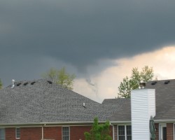
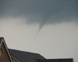
Below, are a few examples of cold air funnels that were photographed here in Kentucky.
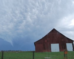
The first photo was near Smiths Grove back on Oct. 25, 2008 (Jason Berry/WBKO).
The second photo was in Hillview, KY on April 17, 2003 (Mark Simpson).
The last photo was in Lexington, KY on May 5 2007 (Alan Creech via Chris Bailey at WKYT).
**All 3 photos are from the NWS website***
I hope you enjoyed this blog a little more than my previous ones. If you have questions of a certain type of weather/weather phenomenon that you want to know more about, feel free to email me and let me know! Sometime soon, I am thinking of doing a blog about some weather folklore, so if you have any old weather tales/folklore you want to share, I would love to see those!
Send me your comments/questions to: crystal@shorelinestations.com!
Thanks for taking time out to read my blog! Have a great day!
-Crystal